8 Day Rwenzori Mountain Trekking (Weismann peak)

Overview

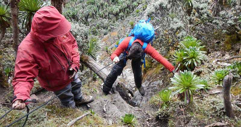
Despite the common extreme weather conditions like the un-predicated rains, our Rwenzori itineraries caters for both capable mountaineers and less-experienced hikers. Whether you want to conquer Africa’s third highest mountain with an attempt on Margherita Peak, or simply take the dramatic scenery en route to 6 Day Weismann’s Peak, our Rwenzori mountains trekking itineraries will take you deep into these unforgettable mountains.

When to trek the Rwenzoris?

The Rwenzori massif is characterized by heavy rainfalls, which can make trekking conditions difficult. The dry season is during the months June-August and December-February, but even during these months you should come prepared for the possibility of heavy rainfall. Don’t allow anything to prevent you from conquering these fabled mountains of the moon during this rwenzori mountains trekking experience.

Planning your Rwenzori mountains trekking- things to consider

Fitness and medical issues

Rwenzori trek tours require a good level of fitness. You will be asked about your general health when you book your trek. Altitude sickness can be a problem for many people. It’s highly recommended that you consider taking a day off mid-climb, to acclimatize to the high altitude.

Insurance

If you’re planning to climb the Ruwenzori’s, particularly if you are climbing Margherita, you are advised to take out travel insurance.

Emergency contacts

You will need to provide these when you sign the disclaimer form before starting your trek.

Getting ready for the safari– what to know

Hiring a Porter

Porters are allowed to carry a maximum of 15 kg each. This will include your clothes, hiking and camping equipment and all your food. The porters will collect firewood and water every evening for you at camp so you only need to carry one day’s personal supply of drinking water at a time.

Ranger guides

Since you will be walking in the Rwenzori Mountains National Park, you will be allocated two or more armed Uganda Wildlife Authority rangers who will act as your guides throughout the trip.

Walking pole

Invaluable! No need to spend money on one of those fancy walking poles, just ask one of the guides to cut down a piece of bamboo for you.

Waterproof clothing

High quality water proof clothing will be very important for you since the rains on the mountain may sometimes go on for days.

Footwear

Hiking boots with ankle support are the best option. If you plan to wear Wellington ‘gum’ boots, get some good insoles. Ankle-high boots with gaiters are recommended as they will keep out a lot of rain and water (and most insects).

What to carry in your day pack

Your day pack (personal rucksack) should contain your waterproof jacket and waterproof trousers, drinking water, sunscreen, mosquito repellent and snacks.

Snacks

Stock up on plenty of your favorite snacks. G’ nuts (groundnuts), biscuits, bananas and dried fruit will give you more energy than chocolate and sweets.

Water

To keep hydrated at altitude, you will need to drink at least two litres of drinking water per day, even in cold weather. The porters collect and boil water every night. By the time you drink it the next morning, it will have cooled nicely.

 Hot water bottle

Since it is usually cold up in the mountains, it is always advisable to carry a hot water bottle.

Trek Summary

  • Day 1: Transfer from Entebbe to Kasese by road driving through beautiful landscape of coffee farms, Tea plantations, roadside fruit and vegetable markets. The drive is about 7 hours with a lunch break en-route via fort portal.
  • Day 2: Your trek starts at the Trekkers Hostel in Kyanjuki, Kilembe which is 12km from Kasese town. You will meet with your climb team at 8:30am for a final kit check and briefing, before setting off on foot from the Trekkers Hostel. The walk is approx. 9.5 km with an expected timeframe of about 5 to 7 hours. The start height is 1,450 metres, climbing to 2,598 metres, where sleep at Sine Hut which is at a height of 2,596 meters is usually conducted.
  • Day 3: Commence walking after a hearty breakfast. Today’s trail climbs steadily to begin with, as you enter the bamboo zone and then continue onto a steep moss-covered ridge about 200m in height. At around 8:30am, trekking starts and you enter the Bamboo-Mimulopsis Zone which is a steep climb with many high steps.
  • Day 4: Your starting height today is 3,590 metres, climbing to 4,200 metres on the top of the confluence between the Nyamwamba and Namusangi Valleys, before dropping to Bugata Camp at 4,100m. Trekking along the valley floor, you will pass small bogs and giant lobelias. Both sides of the valley are lined with sheer cliff faces as we near the confluence of the Nyamwamba and Namusangi Valleys.
  • Day 5: Today is a rest and acclimatisation day, though with the option of an acclimatisation trek to a high pass if you are feeling strong.
  • Day 6: Leaving camp after breakfast, you continue along the valley with fantastic views of the Namusangi below. The last half kilometre to the ridge is a steep climb. The total distance is 9km with a time frame of 4 to 6 hours.
  • Day 7: Descend to Kilembe. Today’s trail is long but downhill all the way, as you cross the Nyamwamba Valley, then continue through the bamboo forest and down the ridge to the Ranger’s Post.
  • Day 8: Your itinerary ends this morning at Marafiki Safari Lodge. We will transfer back to Entebbe for your flight back home.

Itinerary

7 hours Journey
Hotel (mid-range), Trekkers Hostel (Budget)
Dinner
You will then be briefed by the guide about tomorrow.

At approx. 9:30am, the trek may start, although there may be some delays of up to 1 hour. Therefore, leaving the Trekkers’ Hostel at approx. 10am, you walk 2.2km to the UWA rangers post at 1,727m, where you will be briefed on the rules of the Rwenzori National Park. The walk to the post takes about an hour. From the ranger’s post, the trail leads you through tall grasses and ferns of the Afro Montane forest zone into magnificent rainforest. The forest in this region of the Rwenzoris is largely untouched. Many birds can be heard and seen in this rich environment, as well chimpanzees, blue monkeys and troupes of black & white Colobus monkeys. There are also rare sightings of the L’Hoest monkeys which are part of the Bukonzo cultural emblems and are protected by the virtue of the King locally called Omusinga.

Upon entering the forest, the first few kilometers of the trail climb steadily, crossing several small streams and rivers. There are a wide variety of plant species from forest trees to bamboos thickets, low shrubs, flowers, fungi, and much moss and lichen-covered vines hanging from the tall trees. The trail becomes gradually steeper as you approach the bamboo zone. Enock’s Falls are just 150-200 meters from Sine Hut, where you will ascend to camp for the night. Sine Hut is set between tall forest trees and is located just below the bamboo zone on a narrow ridge. Here, you can enjoy the beauty of the Afro Montane forest while you look down at the fantastic waterfalls, or simply enjoy the warmth at a campfire.

9.5km
Lunch and Dinner

The thick moss covering the ground and rocks is spectacular and we ask you to help preserve this pristine environment by keeping to the trail. Please note that during the rainy season this section of the trail becomes very muddy and slippery making the going slow – rubber boots are essential!

As you near the top of the ridge and exit the bamboo forest, you’ll be greeted with stunning views of the valleys and hills below, stretching as far as Lake George and Queen Elizabeth National Park.

You’ll be in the giant heather-rapanea zone at this point, as you approach Kalalama Camp (3,150m), perched on a high ridge overlooking the Kilembe Valley and Kasese town. Here, you can take a rest and a cup of coffee.

After a rest at Kalalama Camp, continue along an undulating trail to Mutinda Camp. The trial becomes less steep from here on out but meanders up and over several small knolls along a ridge top then drops down the side of the valley before climbing again. In doing so, you cross several small streams and pass close to moss covered waterfalls. You then climb steadily along the side of a beautiful mossy river which tumbles down over the rocks under the Giant Heather trees whose trunks are covered in green moss with old man beards (Usnea lichen) hanging from the branches. The trail twists and turns as you climb up the deep valley, which has an enormous variety of plants and flowers. This valley is unique with many Giant Heather trees. Expect to reach Mutinda Camp (3,590m) late afternoon.

In the afternoon you may wish to climb up to the top of the Mutinda Lookout (one to two hours up and one hour down) here, you may stand on moss covered rocks at 3,925 meters with views across the Rwenzori Mountains and down to Kasese town and Lake George.

6.1 km
Camp
Lunch and Dinner

The trail here is boggy particularly in the wet season but with a little skill you can step from tussock to tussock to make the going easier. There are several boardwalks across the worst of the bogs to make going easier. You cross the Mutinda valley through the tussock grass and everlasting flowers interspersed with many Giant Lobelias before climbing a steep section up to the Namusangi Valley (3,840 meters), which ends abruptly with sheer waterfalls and fantastic views of Mutinda Peaks. The Namusangi Valley is wide, with many ups and downs and crossing several bogs as the trail climbs steadily to Bugata Camp at 4,100 meters. Bugata Camp is situated way up Bamwanjara Pass high above Bugata Lake with views across Lake Kopello to Weismann’s Peak, which is often covered with snow then down the valley views of Lake Africa and Lake Kanganyika and the many small peaks towards Mutinda Camp. There are a many Red Forest Duiker (Cephalophuc nigrifrons rubidus) which are a sub-species only found in the Rwenzori Mountains.

Bugata Camp has good facilities, solar lights, good toilets and bathrooms where the guides may prepare some warm water in a basin for you to wash. Bugata also has a helicopter pad (GPS reading N 18.312 E29 53.457) in case of any need for rescue by helicopter but be warned that a helicopter in Uganda costs around $10,000 per hour flying time which is way more than other countries so you need insurance in case of rescue.

8.6 km
Camp
Lunch and Dinner

The optional trek will take approx. 2 hours. Starting at 4,100m, you will climb to the top of the Bamwanjara Pass (4,450m), from where, on a clear day, you’ll be able to enjoy spectacular views of Mts Stanley and Baker, and also the Kachope Lakes.

After time to rest and take in the view, return to camp for lunch and a chance to rest up in advance of tomorrow’s summit climb.

Camp
Lunch and Dinner

The climb to the top of Weismann, while not technical, involves a steep ascent on solid rock – it is important to follow the advice of your climb guides and not to rush during the ascent. It is normally safe to climb without ropes, but in the event of icy conditions, your guides will employ fixed ropes to ensure a safe ascent. The trek starts by walking across the hillside below high cliffs above Bugata Lake then around a ridge point to Lake Kopello where we walk along the edge of the lake which according to researchers the water temperature averages 2˚C As you climbing you get excellent views of the four lakes along the valley below. The last section to the peak is steep on solid rock and can be difficult when snowing or iced up and it may be necessary to use ropes for safety. On a clear day, your reward for summiting will be wonderful views towards the Kachope Lakes below and to Mts Baker and Stanley in the distance. The top of Weismann’s Peak is relativity flat or dome-shaped with deep moss growing on the rocks creating a beautiful atmosphere.

From the summit of Weismann Peak (4,620m), it is possible to trek across the moss-covered dome-shaped ridge to Stella Peak (4,635m) but needs full technical and a good head for heights. After taking in the views, descend to Kiharo Camp (3,430m) down the Nyamwamba Valley. At the head of the valley, there is a large area of thick Giant Groundsel with dense evergreen undergrowth and moss with the rocky peaks towering above which creates its own microenvironment. At night you may stay in Kiharo Camp at 3,460 meters an area rich in evergreen plants and babbling streams. Particularly during the dryer months the night, the air is filled with the calls of the rock hyrax as they sit in the rocky cliffs high above.

9 km
Camp
Lunch and Dinner

The trail down the Nyamwamba Valley is mostly downhill and absolutely stunning with beautiful views. A few kilometers from Kiharo Camp the path turns off to the right to pass along the river. If you wish you may prefer to walk down the river itself hopping across the rocks as you pass down. A few kilometres down the river it becomes very steep with multitudes of waterfalls so there’s usually need to move away from the river and follow a narrow ridge to bypass steep sections. At the bottom, you again meet the river where there is a huge rock shelter called Riverside Rock Shelter where you have lunch. After crossing a small stream you climb up a gentle slope as it is way too steep close to the river. You then reach for the Ranger’s post for debriefing.

After debriefing, it is a short walk down to the Trekkers Hostel.

After lunch and rest at the Trekkers Hostel, you will be collected by your driver/guide for the short transfer to Marafiki Safari Lodge which borders Queen Elizabeth National Park.

Dinner and overnight Marafiki Safari Lodge.

14.6 km
Marafiki Safari Lodge (Mid-range)
Dinner

    Travelers’ Reviews